Sorry, I'm not technically-minded as far as satellites are concerned, but aren't they stationary above their selected point on the Earth?
Yes. So what?
By being placed at an orbital altitude of 22¼ thousand miles above the equator, the satellite orbits at the same rate as the Earth spins so maintains the same position in the sky day in, day out (according to wherever you happen to be), with the clear benefit for a communications satellite that a ground-based antenna doesn't need a motorised pointing mechanism to maintain contact.
Maybe you don't know what skew is. I'm simplifying, but you can think of radio waves as oscillating in a plane. Imagine the two of us holding the ends of a rope: you can waggle the rope and send waves along the rope to me, and you could waggle the rope up and down or side to side (or anywhere in between). What you are sending me is a polarised wave, in the plane you have selected.
If we pass the rope through a slit between you and me, the slit will block the element of the oscillation which is perpendicular to the slit. So if the waggles are in the vertical plane, they will be blocked if the slit is horizontal. If the waggles were at 45º, some of the waggle gets through the slit but what arrives to me is now horizontal.
That's what V and H mean for the satellite transmission channels: is the carrier wave vertically or horizontally polarised. By using both, twice the number of channels can be accommodated because any one frequency can then carry two channels. The LNB has two receivers, one for vertical and the other for horizontal polarisation, and they need lining up correctly with the directions the satellite considers V and H. If they are off, the H signal bleeds through to the V receiver (and vice versa), and the two channels being carried interfere with each other. The amount of signal received also reduces. (It's also important the V LNB receives the V signals – not the H signals, and vice versa – otherwise the set top box will get mightily confused.)
So skew is the difference between your local vertical and the satellite's idea of vertical. The two are likely to be the same if you are on the same longitude as the satellite, but that's not generally the case. For a satellite away from your longitude, the skew will vary according to your latitude.
With a bit of work I could produce an equation to work out the relative skew at any particular latitude and longitude according to the longitude of the satellite, but I would be amazed if such an equation is not already available.
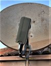
So it seems likely that the 3 on the sky lnb is actually about 18°.
Indeed, ±4.5º per graduation (although the photo appears 5º off that).


")