• The forum software that supports hummy.tv has been upgraded to XenForo 2.3!

    Please bear with us as we continue to tweak things, and feel free to post any questions, issues or suggestions in the upgrade thread.

Skew angle.

Mac

New Member
I am replacing my LNB.
My new one has the skew angles set out in degrees (45 - 0 - 45) whereas my old one is set out in 1,2,3,4,5. (Currently set at "3", although I am in Zone 4 - North of Scotland, according to the excellent satcure co site.)
Can anyone help with a conversion from just numbers to degrees and help me with the correct setting for Zone 4?
Thanks.
 
As I have little satellite experience I have hesitated to respond, but...

I believe Zone 4 only indicates how far off the beam footprint you are, and therefore how large a dish you need. I don't think the zone number relates to skew.

The skew angle will be affected by how far east or west of "normal" you have to point your dish, and (like the dish pointing itself) can be tweaked for best signal strength. A cheap satellite alignment meter will help enormously.

Considering your previous skew scale went from 1-5 over (presumably) the same +/-45º range of adjustment, I suggest 0 on the new scale is equivalent to 3 on the old scale. Set it to 0, then tweak either way while checking signal strength with a meter or on the receiver.
 
Thanks for your reply and interest.
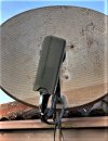
The first photo shows my existing LNB set up by Sky (when I was a subscriber) and conveniently using the fixing bracket as a reference locating point. The markings are on the side of the LNB.
The second photo shows my replacement LNB which has the markings on top of the unit and in degrees.
The third photo (from the satcure site) shows my zone (North of Scotland) as being in Zone 4. I was under the impression that this referred to the skew angle of the LNB as opposed to the dish.
My intention was to replace the new unit and, using a photo taken before I take the old unit out, line up the new one.
Despite much searching on the 'net, I just couldn't find anywhere which gave me a table showing definitive angles for my area. My best guesstimate was going to be around 18.5 degrees.
Once again, much obliged for your contribution.
 

Attachments

  • SATELLITE DISH - G  IMG_0941 (1).jpg
    SATELLITE DISH - G IMG_0941 (1).jpg
    279.6 KB · Views: 11
  • SATELLITE - SL4K LNB - IMG_0956 (1).jpg
    SATELLITE - SL4K LNB - IMG_0956 (1).jpg
    444.7 KB · Views: 11
  • SKEW SETTINGS FOR SKY OR FREESAT - UK .png
    SKEW SETTINGS FOR SKY OR FREESAT - UK .png
    13.5 KB · Views: 14
OK, well maybe you shouldn't call it "Zone" then (and the Satcure LNB Skew page doesn't refer to zones either). I have seen Zone 1 and Zone 2 as referring to the signal strength areas of the footprint.

Judging from your photos, 1-5 are very fine adjustments. The markings on the universal LNB allow for the skew to be adjusted over the maximum range it could ever need, but the 1-5 are only a very small fraction of that with 3 appearing to equate to 0º (and reinforcing the notion that the satellite transponder is preset to require a skew of zero over the centre region of its footprint). A more detailed analysis suggests the notches are at 5º (or maybe 4.5º) increments.

All in all, I would say you need to set your skew to 5º (to equate with "4" in the skew map), and then tweak it according to results.

The correct skew within a few degrees won't make much difference to the signal level for any particular channel, but it will make a huge difference to the rejection of signals on the opposite polarisation. What's needed is to minimise the break-through of V signals on the H feed (and vice versa).
 
(Edit: I must have been typing simultaneously with BH above. I think we concur.)

I'm not a satellite expert either, but that tricolour map intrigued me.
After a little digging I think the skew may be compensation for the earth's curvature.
The satellites are in the sky well to the east so the beams point diagonally across the country. In the middle of that area the beam polarisations will be vertical and horizontal to the ground, but as you move left and right a dish mounted vertical to the earth will actually be tilted at an angle to the beam polarization and the skew is to allow the lnb to be turned a little to realign the polarization.
Zone 3 looks to be about 5° wide, so in that case going from the centre of 3 to the centre of 4 is going to be about a 5° skew, though if only just in 4 it would be about 3°.
The markings on the Sky lnb above seem to fit that as they are only a few degrees per digit.
So I'd expect to set the new lnb to about 4°, though I can't easily describe the direction - clockwise looking forward the satellite?
 
I think the skew may be compensation for the earth's curvature.
That's one way to describe it. The satellite is in a geostationary orbit at some point over the equator, and somewhat to the east of the Greenwich meridian (I don't know why, maybe to create the best beam footprint). So we're all squinting at it sideways to varying degrees, therefore we don't all have the same idea of "vertical".
 
Thank you for both your comments, gents, I now have a starting point of between 4° and 5°.
I also took a photo from the front to give me an idea of the existing skew.
As it happens, the 20-odd year old LNB wasn't the problem with my signal and I have now rectified the fault but will be replacing the unit when better weather arrives!
 

Attachments

  • SATELLITE - LNB - A  IMG_0948 (1).jpg
    SATELLITE - LNB - A IMG_0948 (1).jpg
    137.1 KB · Views: 10
Hmph. That's blown my hypothesising out of the water - your existing skew looks like about 13º to me. I grant the angle might appear exaggerated if taken from below rather than face on, but even so I can't reconcile 5º actual with 13º apparent.
 
Hmph. That's blown my hypothesising out of the water - your existing skew looks like about 13º to me. I grant the angle might appear exaggerated if taken from below rather than face on, but even so I can't reconcile 5º actual with 13º apparent.
When I took the photo I was aware that I had to take it with as little ambiguity as possible, so I used the dish supporting pole as a reference. ( I suppose I could have got more height and positioned it in the middle of the dish!)
That's why I was thinking along the lines of the teens° rather than single figures.
I'm still surprised that there isn't some sort of table produced with suggested skew angles for the U.K. (Sorry, I'm not technically-minded as far as satellites are concerned, but aren't they stationary above their selected point on the Earth?)
 
While trawling to try and understand this I found this reference:

"Skew varies from about 15º in the north of Scotland to around 22º in the south west of England, always rotate clockwise as viewed facing the front of the dish.

Most commercial satellite dishes have a certain amount of skew built in, the LNB will appear to be lopsided.
"

So it seems likely that the 3 on the sky lnb is actually about 18°.
I'm still not sure about the ± direction though - almost all the info seems to avoid any explanation of the science behind skew.
Edit: I think I've got it now. For your new lnb you will probably need to do as above, rotate clockwise as viewed facing the front of the dish, from 0 to 15°.
 
Last edited:
  • Like
Reactions: Mac
I bet the time taken with all this talk is vastly longer than: just whack the new lnb in, turn on your box, start skewing the lnb until you get a pic, finish, have a brew
 
  • Like
Reactions: Mac
Sorry, I'm not technically-minded as far as satellites are concerned, but aren't they stationary above their selected point on the Earth?
Yes. So what?

By being placed at an orbital altitude of 22¼ thousand miles above the equator, the satellite orbits at the same rate as the Earth spins so maintains the same position in the sky day in, day out (according to wherever you happen to be), with the clear benefit for a communications satellite that a ground-based antenna doesn't need a motorised pointing mechanism to maintain contact.

Maybe you don't know what skew is. I'm simplifying, but you can think of radio waves as oscillating in a plane. Imagine the two of us holding the ends of a rope: you can waggle the rope and send waves along the rope to me, and you could waggle the rope up and down or side to side (or anywhere in between). What you are sending me is a polarised wave, in the plane you have selected.

If we pass the rope through a slit between you and me, the slit will block the element of the oscillation which is perpendicular to the slit. So if the waggles are in the vertical plane, they will be blocked if the slit is horizontal. If the waggles were at 45º, some of the waggle gets through the slit but what arrives to me is now horizontal.

That's what V and H mean for the satellite transmission channels: is the carrier wave vertically or horizontally polarised. By using both, twice the number of channels can be accommodated because any one frequency can then carry two channels. The LNB has two receivers, one for vertical and the other for horizontal polarisation, and they need lining up correctly with the directions the satellite considers V and H. If they are off, the H signal bleeds through to the V receiver (and vice versa), and the two channels being carried interfere with each other. The amount of signal received also reduces. (It's also important the V LNB receives the V signals – not the H signals, and vice versa – otherwise the set top box will get mightily confused.)

So skew is the difference between your local vertical and the satellite's idea of vertical. The two are likely to be the same if you are on the same longitude as the satellite, but that's not generally the case. For a satellite away from your longitude, the skew will vary according to your latitude.

With a bit of work I could produce an equation to work out the relative skew at any particular latitude and longitude according to the longitude of the satellite, but I would be amazed if such an equation is not already available.

So it seems likely that the 3 on the sky lnb is actually about 18°.
Indeed, ±4.5º per graduation (although the photo appears 5º off that).
 
Last edited:
  • Like
Reactions: Mac
"Skew varies from about 15º in the north of Scotland, always rotate clockwise as viewed facing the front of the dish.
So it seems likely that the 3 on the sky lnb is actually about 18°.
rotate clockwise as viewed facing the front of the dish, from 0 to 15°.
Agreed! Thanks.
 
With a bit of work I could produce an equation to work out the relative skew at any particular latitude and longitude according to the longitude of the satellite, but I would be amazed if such an equation is not already available.
I've already run into a problem with this, because it will depend on the orientation of the satellite's "V" in two dimensions. Ugh! Perhaps that's why the sources gloss over it.
 
I think I've got it now. For your new lnb you will probably need to do as above, rotate clockwise as viewed facing the front of the dish, from 0 to 15°.
Quite. Think of a satellite due south where skew will be zero. If you now move that satellite to the east, its apparent orientation rotates anticlockwise (as viewed from behind the dish), therefore the LNB needs to skew clockwise (viewed from the satellite, ie in front of the dish).
 
Quite. Think of a satellite due south where skew will be zero. If you now move that satellite to the east, its apparent orientation rotates anticlockwise (as viewed from behind the dish), therefore the LNB needs to skew clockwise (viewed from the satellite, ie in front of the dish).
In principle, yes. But the satellites are (more or less) 28° East and the skew is only around 18. So it's not simple, unsurprisingly.
I did spherical trigonometry at school which might help ... if I could remember any of it :)

Then again, maybe the satellites don't transmit the signal truly V&H in the first place - they 'pre-skew' it perhaps.
 
Then again, maybe the satellites don't transmit the signal truly V&H in the first place - they 'pre-skew' it perhaps.
That was my thought too, until it turned out the Sky LNB has offset graduations (although maybe "0" would equate with 0º skew).

In principle, yes. But the satellites are (more or less) 28° East and the skew is only around 18. So it's not simple, unsurprisingly.
I was only rationalising the direction of rotation, not the magnitude of it, but as an amateur astronomer (now relegated to bystander) I can imagine the graduations of the celestial sphere and the sort of angle the lines of Right Ascension make in the sky. That's what I would base my skew equation on.
 
Then again, maybe the satellites don't transmit the signal truly V&H in the first place - they 'pre-skew' it perhaps.
That was certainly true for some satellites - some were skewed more than others. Can't remember which now and it's irrelevant as none of them were used for DTH TV.
Skew is critically important for uplink; for downlink less so, but still needs to be reasonably right for the reasons BH gave.
 
I don't know if it might help - when working out settings for my satellite setups in England and Spain, I found dishpointer.com very useful. I just revisited the site and found it can now work from postcodes as well (didn't use to do that)
Derek
 
  • Like
Reactions: Mac
Back
Top